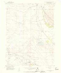
1955 Map of Mac Farlane Reservoir
USGS Topo · Published 1957About this map
The Illinois River flows through this 1955 landscape, where an intricate network of irrigation systems like the Oklahoma Ditch No 1 and Midland Ditch support high-altitude ranching. Ranching families have left a significant mark on the terrain, with the Hackley Ranch, Allard Ranch, George Allard Ranch, and Seymour Ranch dispersed across the valley floor. The presence of the Union Pacific rail line and the abandoned Larand School at the base of Owl Ridge suggests a community that was once more closely tied to the railroad and rural education.
Find a feature on this map
31 named features on this map. Tap any name to fly to it.
Don’t see what you’re looking for? This feature index may not catch every label — zoom into the map to look around manually.
Map Details
Editions of this 1955 Mac Farlane Reservoir Map
5 editions found
Other maps of this area

1954 · Craig
USGS Topo · 1:250,000

1955 · Delaney Butte
USGS Topo · 1:24,000

1955 · Coalmont
USGS Topo · 1:24,000

1955 · Owl Ridge
USGS Topo · 1:24,000

1955 · Gould NW
USGS Topo · 1:24,000

1955 · Walden
USGS Topo · 1:24,000

1955 · Mac Farlane Reservoir
USGS Topo · 1:24,000

1955 · Walden
USGS Topo · 1:62,500

1956 · Spicer Peak
USGS Topo · 1:24,000

1956 · Buffalo Peak
USGS Topo · 1:24,000