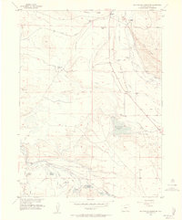
1955 Map of Macfarlane Reservoir
USGS Topo · Published 1978About this map
The Illinois River meanders through this landscape in North Park, flanked by the prominent Peterson Ridge and Owl Ridge. The area is characterized by an extensive network of irrigation infrastructure essential for high-altitude ranching, including the Midland Ditch, Oklahoma Ditch No 1, and Baldwin Ditch. Family ranching operations are the primary centers of activity, with sites like Allard Ranch, Hackley Ranch, and Ish Ranch dotting the terrain. Evidence of a changing local population is visible at Larand School, which sits near the small settlement of Larand. A variety of water storage projects are captured in this mid-century survey, from the centrally located Mac Farlane Reservoir to smaller cattle-country impoundments like Hap Reservoir and Addison Reservoir. The Union Pacific line cuts through the northern section, marking the primary transport artery through this part of Jackson County.
Find a feature on this map
33 named features on this map. Tap any name to fly to it.
Don’t see what you’re looking for? This feature index may not catch every label — zoom into the map to look around manually.
Map Details
Editions of this 1955 Macfarlane Reservoir Map
5 editions found
Other maps of this area

1954 · Craig
USGS Topo · 1:250,000

1955 · Delaney Butte
USGS Topo · 1:24,000

1955 · Coalmont
USGS Topo · 1:24,000

1955 · Owl Ridge
USGS Topo · 1:24,000

1955 · Gould NW
USGS Topo · 1:24,000

1955 · Walden
USGS Topo · 1:24,000

1955 · Mac Farlane Reservoir
USGS Topo · 1:24,000

1955 · Walden
USGS Topo · 1:62,500

1956 · Spicer Peak
USGS Topo · 1:24,000

1956 · Buffalo Peak
USGS Topo · 1:24,000