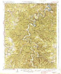
1939 Map of Macks Creek
USGS Topo · Published 1939About this map
Hahatonka Castle stands near the confluence of the Niangua River and Lake of the Ozarks, anchoring a landscape defined by deep limestone hollows and subterranean wonders. This 1939 survey captures the region just as the recently created reservoir began to reshape local geography, while many traditional river crossings like Rodger Ford, Turner Ford, and McPheters Ford remained critical for overland travel. The map reveals a dense network of rural infrastructure, including dozens of country schools such as Chapel Bluff Sch and Hickory Hill Sch, alongside community centers like Kirk Chapel. Geologic interests are well-marked, from River Cave and Island Cave to the dramatic Red Sink. The presence of the Tunnel Dam on the Niangua highlights early hydroelectric development, while the winding course of the Little Niangua River flows past remote settlements like Leadmine and Prosperine.
Find a feature on this map
128 named features on this map. Tap any name to fly to it.
Don’t see what you’re looking for? This feature index may not catch every label — zoom into the map to look around manually.
Map Details
Editions of this 1939 Macks Creek Map
2 editions found

Other maps of this area

1884 · Bolivar
USGS Topo · 1:125,000

1887 · Warsaw
USGS Topo · 1:125,000

1888 · Versailles
USGS Topo · 1:125,000

1892 · Bolivar
USGS Topo · 1:125,000

1893 · Versailles
USGS Topo · 1:125,000

1894 · Warsaw
USGS Topo · 1:125,000

1932 · Versailles No 4
USGS Topo · 1:48,000

1933 · Stoutland
USGS Topo · 1:62,500

1934 · Macks Creek
USGS Topo · 1:48,000

1934 · Camdenton
USGS Topo · 1:24,000