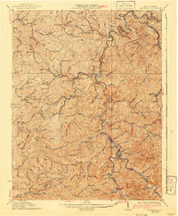
1931 Map of Madison
USGS Topo · Published 1940About this map
Madison and Danville serve as the central hubs of this 1930s landscape, positioned where the Pond Fork and Spruce Fork converge to form the Little Coal River. The region's development is closely tied to the winding path of the Chesapeake and Ohio RR, which follows the river valleys through steep terrain marked by Brushy Knob and Workman Knob. This era of West Virginia's history is reflected in the dense network of rural infrastructure, including numerous one-room schoolhouses like Sugartree Bark Sch and Slabtown Sch, and small religious centers such as Pine Grove Ch. The map details a period when timber and coal interests were shaping the expansion of small settlements like Julian, Morrisvale, and Sumerco. The geography is defined by a intricate system of hollows and branches, such as Pigeonroost Fork and Lick Creek, which dictated the location of family homesteads and the early road network before modern highway expansion.
Find a feature on this map
168 named features on this map. Tap any name to fly to it.
Don’t see what you’re looking for? This feature index may not catch every label — zoom into the map to look around manually.
Map Details
Editions of this 1931 Madison Map
3 editions found

Other maps of this area

1887 · Warfield
USGS Topo · 1:125,000

1891 · Oceana
USGS Topo · 1:125,000

1891 · Warfield
USGS Topo · 1:125,000

1892 · Huntington
USGS Topo · 1:125,000

1893 · Oceana
USGS Topo · 1:125,000

1898 · Huntington
USGS Topo · 1:125,000

1898 · Oceana
USGS Topo · 1:125,000

1899 · Charleston
USGS Topo · 1:125,000

1902 · Milton
USGS Topo · 1:62,500

1902 · Midkiff
USGS Topo · 1:62,500