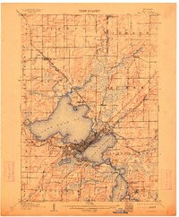
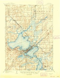
1906 Map of Madison
USGS Topo · Published 1913About this map
The isthmus city of Madison is shown here as the early 20th-century hub of Dane County, defined by its position between Lake Mendota and Lake Monona. The expansion of the city is evident in the dense street grids that reach toward Elmside and the University of Wisconsin campus on the shores of University Bay. Beyond the urban core, the landscape is shaped by the Yahara River and its tributary system, connecting the larger lakes with Lake Wingra and Lake Waubesa.
Find a feature on this map
55 named features on this map. Tap any name to fly to it.
Don’t see what you’re looking for? This feature index may not catch every label — zoom into the map to look around manually.
Map Details
Editions of this 1906 Madison Map
6 editions found

Other maps of this area

1889 · Evansville
USGS Topo · 1:62,500

1890 · Madison
USGS Topo · 1:62,500

1890 · Sun Prairie
USGS Topo · 1:62,500

1890 · Stoughton
USGS Topo · 1:62,500

1892 · Madison
USGS Topo · 1:62,500

1894 · Evansville
USGS Topo · 1:62,500

1895 · Baraboo
USGS Topo · 1:62,500

1896 · Sun Prairie
USGS Topo · 1:62,500

1901 · Poynette
USGS Topo · 1:62,500

1904 · Madison
USGS Topo · 1:62,500