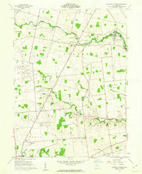
1961 Map of Magnetic Springs
USGS Topo · Published 1962About this map
The village of Magnetic Springs serves as a focal point in this agricultural region of Union County, positioned along the meandering path of Bokes Creek. By the early 1960s, the landscape remained deeply rooted in its rural foundations, evidenced by the numerous family and community cemeteries such as Maple Dell Cem and Maskill Cem that dot the townships of Leesburg and Taylor. The presence of the County Home near Paris township and the Hospital in the north suggests established social infrastructure serving the local population.
Find a feature on this map
30 named features on this map. Tap any name to fly to it.
Don’t see what you’re looking for? This feature index may not catch every label — zoom into the map to look around manually.
Map Details
Editions of this 1961 Magnetic Springs Map
3 editions found
Other maps of this area

1901 · Dublin
USGS Topo · 1:62,500

1903 · Dublin
USGS Topo · 1:62,500

1913 · Richwood
USGS Topo · 1:62,500

1915 · Richwood
USGS Topo · 1:62,500

1916 · Milford Center
USGS Topo · 1:62,500

1924 · Delaware
USGS Topo · 1:62,500

1925 · Delaware
USGS Topo · 1:62,500

1944 · Richwood
USGS Topo · 1:62,500

1944 · Milford Center
USGS Topo · 1:62,500

1944 · Delaware
USGS Topo · 1:62,500