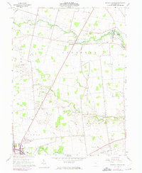
1961 Map of Magnetic Springs
USGS Topo · Published 1974About this map
Magnetic Springs serves as the focal point of this Union County landscape, situated along the winding course of Bokes Creek. The map documents a predominantly agricultural region at the start of the 1960s, punctuated by small crossroads settlements and various institutional landmarks. Near the southwestern corner, the County Home and Woodview Park lie adjacent to the village, while the Blues Creek Ch and several small family burial grounds like Maskill Cem and Scott Cem are scattered across the townships of Leesburg and Paris. Transport patterns reflect a period of transition, featuring the Erie Lackawanna line in the north and an Old Railroad Grade further south, illustrating the changing infrastructure of central Ohio. The detailed inclusion of field lines and property boundaries provides a clear look at the rural land division of the era.
Find a feature on this map
40 named features on this map. Tap any name to fly to it.
Don’t see what you’re looking for? This feature index may not catch every label — zoom into the map to look around manually.
Map Details
Editions of this 1961 Magnetic Springs Map
3 editions found
Other maps of this area

1901 · Dublin
USGS Topo · 1:62,500

1903 · Dublin
USGS Topo · 1:62,500

1913 · Richwood
USGS Topo · 1:62,500

1915 · Richwood
USGS Topo · 1:62,500

1916 · Milford Center
USGS Topo · 1:62,500

1924 · Delaware
USGS Topo · 1:62,500

1925 · Delaware
USGS Topo · 1:62,500

1944 · Richwood
USGS Topo · 1:62,500

1944 · Milford Center
USGS Topo · 1:62,500

1944 · Delaware
USGS Topo · 1:62,500