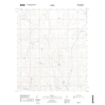
2020 Map of Magnolia
USGS Topo · Published 2020About this map
The settlement of Magnolia and the community of Shiloh anchor this part of Marengo County, where the landscape is defined by the winding tributaries of the Tombigbee River watershed. Numerous family and community burial sites, including Paradise Cem, Mooring Cem, and the Rock Springs Cem, suggest a deeply rooted rural population. The area is interlaced with creeks such as Sweetwater Cr, Beaver Cr, and Turkey Cr, which likely dictated the early paths of local transport. Modern corridors like AL Highway 25 now cut through the terrain once dominated by smaller routes like Marengo Co 47 and Mooring McNeil Rd. The presence of the Pleasant Hill Methodist Church Cem serves as a central landmark for this agricultural and timber-producing region, reflecting the traditional social organization of the Alabama Black Belt.
Find a feature on this map
51 named features on this map. Tap any name to fly to it.
Don’t see what you’re looking for? This feature index may not catch every label — zoom into the map to look around manually.
Map Details
Editions of this 2020 Magnolia Map
This is the sole edition of this map. No revisions or reprints were ever made.
Other maps of this area

1953 · Montgomery
USGS Topo · 1:250,000

1956 · Montgomery
USGS Topo · 1:250,000

1957 · Montgomery
USGS Topo · 1:250,000

1968 · Thomaston East
USGS Topo · 1:24,000

1968 · Thomaston West
USGS Topo · 1:24,000

1970 · Linden
USGS Topo · 1:24,000

1978 · Surginer
USGS Topo · 1:24,000

1978 · Sweet Water
USGS Topo · 1:24,000
1978 · Flatwood
USGS Topo · 1:24,000
1978 · Miller
USGS Topo · 1:24,000