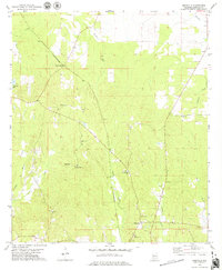
1978 Map of Magnolia
USGS Topo · Published 1979About this map
St Louis-San Francisco tracks run diagonally through this Marengo County landscape, serving the community at Octagon Station and the settlement of Magnolia. This 1970s survey captures a rural Alabama interior defined by its dispersed religious and civic centers, including Mt Pilgrim Ch and its associated Mt Pilgrim Cem, alongside others like Rock Spring Ch and New Hope Ch. The terrain is deeply etched by a network of waterways including Beaver Creek, Turkey Creek, and James Creek, which feed into the local bottomlands. Small-scale industrial activity is noted at a Gravel Pit near the southern edge of the map, while Marengo Lake provides a distinct landmark in the western section. The placement of Mooring Cem and several unnamed cemeteries highlights the area's long-standing genealogical footprint.
Find a feature on this map
24 named features on this map. Tap any name to fly to it.
Don’t see what you’re looking for? This feature index may not catch every label — zoom into the map to look around manually.
Map Details
Editions of this 1978 Magnolia Map
This is the sole edition of this map. No revisions or reprints were ever made.
Other maps of this area

1953 · Montgomery
USGS Topo · 1:250,000

1956 · Montgomery
USGS Topo · 1:250,000

1957 · Montgomery
USGS Topo · 1:250,000

1968 · Thomaston East
USGS Topo · 1:24,000

1968 · Thomaston West
USGS Topo · 1:24,000

1970 · Linden
USGS Topo · 1:24,000

1978 · Surginer
USGS Topo · 1:24,000

1978 · Sweet Water
USGS Topo · 1:24,000
1978 · Flatwood
USGS Topo · 1:24,000
1978 · Miller
USGS Topo · 1:24,000