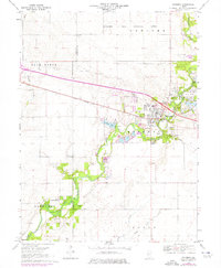
1970 Map of Mahomet
USGS Topo · Published 1976About this map
The Sangamon River carves a winding path through the center of this Illinois landscape, serving as a primary corridor for both industry and recreation. In the village of Mahomet, the river is flanked by the Lake of the Woods County Forest Preserve, featuring a Covered Bridge, Museum, and Golf Course. These recreational developments appear alongside industrial sites like numerous Gravel Pit locations and the specialized Mahomet Gas Storage Area to the north.
Find a feature on this map
31 named features on this map. Tap any name to fly to it.
Don’t see what you’re looking for? This feature index may not catch every label — zoom into the map to look around manually.
Map Details
Editions of this 1970 Mahomet Map
3 editions found
Other maps of this area

1907 · Mahomet
USGS Topo · 1:62,500

1928 · Gibson City
USGS Topo · 1:62,500

1937 · Monticello
USGS Topo · 1:48,000

1943 · Monticello
USGS Topo · 1:62,500

1952 · Arrowsmith
USGS Topo · 1:62,500

1957 · Gibson City
USGS Topo · 1:62,500

1957 · Rising
USGS Topo · 1:24,000

1957 · Mahomet
USGS Topo · 1:62,500

1957 · Bondville
USGS Topo · 1:24,000

1958 · Peoria
USGS Topo · 1:250,000