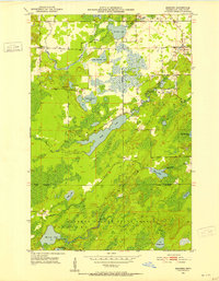
1951 Map of Makinen
USGS Topo · Published 1953About this map
The settlement of Makinen sits at a transportation crossroads in the early 1950s, serving as a focal point for this section of St. Louis County. The landscape is defined by an intricate network of glacial lakes and waterways, including the elongated Long Lake and the winding Paleface River. These water bodies are interspersed with dense woodlands, much of which is protected within the Cloquet Valley State Forest.
Find a feature on this map
26 named features on this map. Tap any name to fly to it.
Don’t see what you’re looking for? This feature index may not catch every label — zoom into the map to look around manually.
Map Details
Editions of this 1951 Makinen Map
5 editions found
Other maps of this area

1951 · Palo
USGS Topo · 1:24,000

1951 · Gilbert
USGS Topo · 1:24,000

1951 · Central Lakes
USGS Topo · 1:24,000

1951 · Makinen
USGS Topo · 1:24,000

1954 · Hibbing
USGS Topo · 1:250,000

1956 · Cotton
USGS Topo · 1:24,000

1956 · Whiteface
USGS Topo · 1:24,000

1957 · Hibbing
USGS Topo · 1:250,000

1957 · Markham
USGS Topo · 1:62,500

1957 · Comstock Lake
USGS Topo · 1:24,000