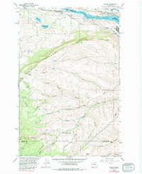
1966 Map of Malaga
USGS Topo · Published 1979About this map
Malaga and the Columbia River corridor dominate this mid-1960s landscape, illustrating the industrial and agricultural development of central Washington. The presence of the Great Northern railroad and the Alcoa facility near the riverbank underscores the area's importance as a transportation and manufacturing hub. Infrastructure is highly detailed, featuring the Keokuk Substation and Valhalla Substation, which supported the regional energy grid.
Find a feature on this map
37 named features on this map. Tap any name to fly to it.
Don’t see what you’re looking for? This feature index may not catch every label — zoom into the map to look around manually.
Map Details
Editions of this 1966 Malaga Map
2 editions found
Other maps of this area

1912 · Malaga
USGS Topo · 1:48,000

1913 · Wenatchee
USGS Topo · 1:62,500

1914 · Malaga
USGS Topo · 1:62,500

1915 · Wenatchee
USGS Topo · 1:62,500

1920 · Colockum Pass
USGS Topo · 1:125,000

1922 · Colockum Pass
USGS Topo · 1:125,000

1957 · Wenatchee
USGS Topo · 1:250,000
1966 · Malaga NE
USGS Topo · 1:24,000

1966 · Rock Island
USGS Topo · 1:24,000

1966 · Wenatchee
USGS Topo · 1:24,000