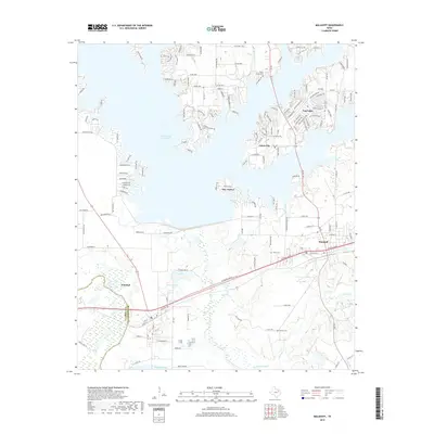
2019 Map of Malakoff
USGS Topo · Published 2019About this map
Cedar Creek Reservoir dominates the northern half of this landscape, its indented shoreline giving rise to several modern waterfront communities including Caney City, Star Harbor, and Log Cabin. Near the western edge, the Trinity River flows past the established settlement of Trinidad, while the eastern portion is anchored by Malakoff. This 2019 survey documents the extensive residential development surrounding the reservoir, characterized by a dense network of roads such as Bayside Cir and Bushwhacker Dr. South of the lake, the terrain transitions into a more rural pattern of creek bottoms and sloughs, including McAllister Slough and Walnut Cr. Local heritage is preserved in several small burial grounds scattered throughout the quadrangle, notably Antioch Cem, Clear Creek Cem, and Stean Cem, which remain as markers of the area's earlier rural settlement patterns before the creation of the reservoir.
Find a feature on this map
150 named features on this map. Tap any name to fly to it.
Don’t see what you’re looking for? This feature index may not catch every label — zoom into the map to look around manually.
Map Details
Editions of this 2019 Malakoff Map
This is the sole edition of this map. No revisions or reprints were ever made.
Other maps of this area

1920 · Kemp
USGS Topo · 1:62,500

1948 · Martins Mill
USGS Topo · 1:62,500

1949 · Martins Mill
USGS Topo · 1:62,500

1949 · Athens
USGS Topo · 1:62,500

1950 · Athens
USGS Topo · 1:62,500

1954 · Dallas
USGS Topo · 1:250,000

1956 · Tyler
USGS Topo · 1:250,000

1957 · Kemp
USGS Topo · 1:62,500

1958 · Dallas
USGS Topo · 1:250,000

1960 · Tool
USGS Topo · 1:24,000