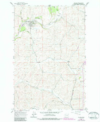
1964 Map of Malden
USGS Topo · Published 1986About this map
The town of Malden serves as the focal point of this mid-century survey, situated at the confluence of Pine Creek and Cache Creek. This area of Whitman County reveals a landscape shaped by both hydrology and transit, where the Union Pacific railroad tracks follow the winding path of Thorn Creek in the south and provide a lifeline for the agricultural and industrial infrastructure of the region. The map documents the distribution of local resources, including numerous Gravel Pits and essential water management features like Water Tanks.
Find a feature on this map
20 named features on this map. Tap any name to fly to it.
Don’t see what you’re looking for? This feature index may not catch every label — zoom into the map to look around manually.
Map Details
Editions of this 1964 Malden Map
2 editions found
Other maps of this area

1903 · Oakesdale
USGS Topo · 1:125,000

1905 · Oakesdale
USGS Topo · 1:125,000

1954 · Cheney
USGS Topo · 1:62,500

1954 · Spangle
USGS Topo · 1:62,500

1955 · Spokane
USGS Topo · 1:250,000

1958 · Spokane
USGS Topo · 1:250,000

1964 · St. John
USGS Topo · 1:24,000

1964 · Malden
USGS Topo · 1:24,000
1964 · Steptoe
USGS Topo · 1:24,000
1964 · Rosalia
USGS Topo · 1:24,000