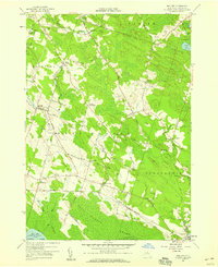
1957 Map of Mallory
USGS Topo · Published 1959About this map
The lowlands of northern Oneida Lake dominate this landscape, where the vast Toad Harbor Swamp and Big Bay Swamp meet the lake shore. Surveyed in the late 1950s, the map reveals a network of rural settlements like Mud Settlement and Dutch Settlement that speak to the region's 19th-century agricultural origins. Toward the east, the Threemile Bay State Game Management Area indicates a shift toward conservation and public land use as formerly farmed wetlands were set aside.
Find a feature on this map
63 named features on this map. Tap any name to fly to it.
Don’t see what you’re looking for? This feature index may not catch every label — zoom into the map to look around manually.
Map Details
Editions of this 1957 Mallory Map
Other maps of this area

1895 · Chittenango
USGS Topo · 1:62,500

1895 · Syracuse
USGS Topo · 1:62,500

1898 · Syracuse
USGS Topo · 1:62,500

1898 · Chittenango
USGS Topo · 1:62,500

1902 · Chittenango
USGS Topo · 1:62,500

1905 · Mexico
USGS Topo · 1:62,500

1906 · Kasoag
USGS Topo · 1:62,500

1940 · Brewerton
USGS Topo · 1:24,000

1940 · Cicero
USGS Topo · 1:24,000

1941 · Cleveland
USGS Topo · 1:24,000