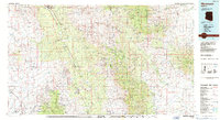
1986 Map of Mammoth
USGS Topo · Published 1987About this map
Mining operations and river valleys dominate this mid-1980s landscape of southern Arizona. The San Pedro River and Gila River corridor serves as the primary artery for settlement, connecting towns like Mammoth and Dudleyville with the industrial hubs of Winkelman and Hayden. Large-scale mineral extraction is a defining characteristic of the era, evidenced by the sprawling San Manuel Mine and prominent Mine Dump labels, alongside older sites such as the Silver Queen Mine and Tiger Mine.
Find a feature on this map
49 named features on this map. Tap any name to fly to it.
Don’t see what you’re looking for? This feature index may not catch every label — zoom into the map to look around manually.
Map Details
Editions of this 1986 Mammoth Map
3 editions found
Other maps of this area

1900 · Florence
USGS Topo · 1:125,000

1902 · Florence
USGS Topo · 1:125,000

1904 · Tucson
USGS Topo · 1:125,000

1905 · Tucson
USGS Topo · 1:125,000

1910 · Ray
USGS Topo · 1:62,500

1911 · Winkelman
USGS Topo · 1:125,000

1913 · Winkelman
USGS Topo · 1:125,000

1915 · Christmas
USGS Topo · 1:62,500

1917 · Christmas
USGS Topo · 1:62,500

1922 · Willcox
USGS Topo · 1:125,000