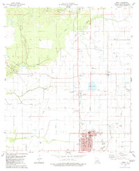
1983 Map of Mamou
USGS Topo · Published 1983About this map
Mamou serves as the cultural hub of this prairie landscape, with the town's street grid surrounding City Hall, a High Sch, and the Savoy Hosp. The surrounding countryside is defined by the energy industry and a network of bayous, where the Pine Prairie Oil and Gas Field and Reddell Oil and Gas Field reveal the importance of mineral extraction to the local economy in the early 1980s. Waterways like Bayou Nezpique and Grand Louis Bayou meander through the flatlands, punctuated by small settlements like Reddell, Vidrine, and Easton. For genealogists, the map is particularly dense with family-named burial sites, including Ardoin Cem, Pinseclair Cem, and Platin Cem, alongside religious landmarks such as St Teresa Ch. This survey documents a transition in land use, where traditional agricultural bayou drainage meets modern infrastructure like the Mamou Municipal Airport.
Find a feature on this map
37 named features on this map. Tap any name to fly to it.
Don’t see what you’re looking for? This feature index may not catch every label — zoom into the map to look around manually.
Map Details
Editions of this 1983 Mamou Map
This is the sole edition of this map. No revisions or reprints were ever made.
Other maps of this area

1935 · Beaver
USGS Topo · 1:31,680

1935 · Turkey Creek
USGS Topo · 1:62,500

1942 · Oakdale
USGS Topo · 1:62,500

1947 · Ville Platte
USGS Topo · 1:31,680

1947 · Fruge Lake
USGS Topo · 1:31,680

1947 · Redland
USGS Topo · 1:31,680

1947 · Chataignier
USGS Topo · 1:31,680

1947 · Bond
USGS Topo · 1:31,680

1949 · Turkey Creek
USGS Topo · 1:62,500

1952 · Lake Charles
USGS Topo · 1:250,000