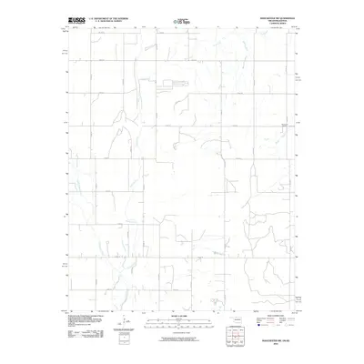
2010 Map of Manchester NW
USGS Topo · Published 2010About this map
Sandy Creek and its tributaries define the hydrology of this rural landscape on the border of Oklahoma and Kansas. The land is organized by a strict geometric grid of section roads, including north-south corridors like N2700 Rd and east-west routes such as E0040 Rd. This infrastructure supports a primarily agricultural region where small watercourses like Rush Creek and Little Sandy Creek meander across the plains. A significant local landmark is the Mennonite Cemetery, located in the northeastern quadrant near the junction of E0040 Rd and Sand Creek. The map illustrates the sparsely populated character of the borderlands during this period, focusing on the essential network of rural roads and natural drainage systems that serve the local farming community.
Find a feature on this map
23 named features on this map. Tap any name to fly to it.
Don’t see what you’re looking for? This feature index may not catch every label — zoom into the map to look around manually.
Map Details
Editions of this 2010 Manchester NW Map
This is the sole edition of this map. No revisions or reprints were ever made.
Other maps of this area

1889 · Anthony
USGS Topo · 1:125,000

1891 · Anthony
USGS Topo · 1:125,000

1955 · Woodward
USGS Topo · 1:250,000

1955 · Pratt
USGS Topo · 1:250,000

1958 · Woodward
USGS Topo · 1:250,000

1959 · Pratt
USGS Topo · 1:250,000

1969 · Amorita
USGS Topo · 1:24,000
1969 · Manchester
USGS Topo · 1:24,000
1969 · Sand Creek
USGS Topo · 1:24,000

1969 · Manchester SW
USGS Topo · 1:24,000