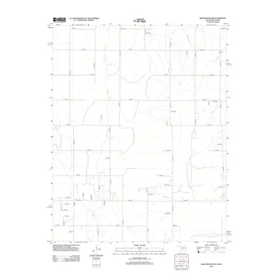
2012 Map of Manchester NW
USGS Topo · Published 2012About this map
Sandy Creek and its tributaries define this agricultural landscape on the border of Oklahoma and Kansas during the early 21st century. The map reveals a strictly regulated section-line road network, such as E0030 Road and N2700 Road, which partitions the terrain for high-plains farming. Local heritage is preserved in small, rural burial grounds like Rosedale Cemetery in the northeast and the Mennonite Cemetery near Sand Creek. The drainage patterns of Rush Creek and Little Sandy Creek provide the only natural breaks in the geometric grid of the plains, illustrating the intersection of natural hydrology and systematic human land division.
Find a feature on this map
45 named features on this map. Tap any name to fly to it.
Don’t see what you’re looking for? This feature index may not catch every label — zoom into the map to look around manually.
Map Details
Editions of this 2012 Manchester NW Map
This is the sole edition of this map. No revisions or reprints were ever made.
Other maps of this area

1889 · Anthony
USGS Topo · 1:125,000

1891 · Anthony
USGS Topo · 1:125,000

1955 · Woodward
USGS Topo · 1:250,000

1955 · Pratt
USGS Topo · 1:250,000

1958 · Woodward
USGS Topo · 1:250,000

1959 · Pratt
USGS Topo · 1:250,000

1969 · Amorita
USGS Topo · 1:24,000
1969 · Manchester
USGS Topo · 1:24,000
1969 · Sand Creek
USGS Topo · 1:24,000

1969 · Manchester SW
USGS Topo · 1:24,000