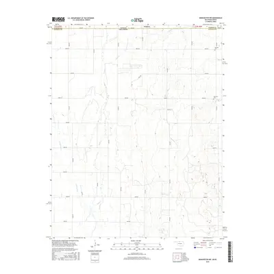
2016 Map of Manchester NW
USGS Topo · Published 2016About this map
Waldron sits at the northern edge of this survey, straddling the border where Harper Co, Kansas, meets Alfalfa Co, Oklahoma. The landscape is defined by the subtle drainage patterns of Sandy Creek and Little Sandy Creek, which flow southward through a grid of rural section roads. This mid-2010s survey documents the enduring agricultural layout of the region, where the section lines dictated by the Public Land Survey System remain the primary corridors for transport, including E0040 Rd and N2700 Rd. For those tracing local heritage, the map identifies two significant burial sites: the Rosedale Cem in the northeast and the Mennonite Cem further south, providing specific geographical markers for family historians studying the settlement patterns of this cross-border community.
Find a feature on this map
29 named features on this map. Tap any name to fly to it.
Don’t see what you’re looking for? This feature index may not catch every label — zoom into the map to look around manually.
Map Details
Editions of this 2016 Manchester NW Map
This is the sole edition of this map. No revisions or reprints were ever made.
Other maps of this area

1889 · Anthony
USGS Topo · 1:125,000

1891 · Anthony
USGS Topo · 1:125,000

1955 · Woodward
USGS Topo · 1:250,000

1955 · Pratt
USGS Topo · 1:250,000

1958 · Woodward
USGS Topo · 1:250,000

1959 · Pratt
USGS Topo · 1:250,000

1969 · Amorita
USGS Topo · 1:24,000
1969 · Manchester
USGS Topo · 1:24,000
1969 · Sand Creek
USGS Topo · 1:24,000

1969 · Manchester SW
USGS Topo · 1:24,000