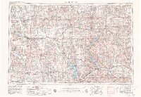
1955 Map of Manhattan
USGS Topo · Published 1980About this map
Fort Riley Military Reservation dominates the confluence of the Republican River and Big Blue River, serving as a massive topographical anchor in northeastern Kansas. This landscape is defined by its deep connectivity, where the Laramie Trail and major rail lines like the Union Pacific RR and Chicago Rock Island and Pacific RR track the paths of ancestral river valleys. The emergence of modern flood control is evident in the presence of Tuttle Creek Lake and Milford Lake, creating vast reservoirs where once only narrow channels flowed near Manhattan and Junction City. From the Flint Hills to the northern settlements of Marysville and Seneca, the map documents a region of established agricultural centers and military installations. Smaller communities such as Blue Rapids, Waterville, and Clay Center are shown in their mid-century context, linked by a dense network of secondary roads and the wandering course of the Little Blue River.
Find a feature on this map
178 named features on this map. Tap any name to fly to it.
Don’t see what you’re looking for? This feature index may not catch every label — zoom into the map to look around manually.
Map Details
Editions of this 1955 Manhattan Map
4 editions found

Other maps of this area

1885 · Eskridge
USGS Topo · 1:125,000

1886 · Junction City
USGS Topo · 1:125,000

1888 · Hiawatha
USGS Topo · 1:125,000

1889 · Burlingame
USGS Topo · 1:125,000

1889 · Seneca
USGS Topo · 1:125,000

1889 · Wamego
USGS Topo · 1:125,000

1889 · Marysville
USGS Topo · 1:125,000

1889 · Junction City
USGS Topo · 1:125,000

1889 · Abilene
USGS Topo · 1:125,000

1889 · Parkerville
USGS Topo · 1:125,000