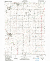
1990 Map of Manhattan
USGS Topo · Published 1991About this map
Manhattan and the surrounding Will County townships appear here during a period of suburban expansion and agricultural preservation in the late 1980s. The village of Manhattan serves as a central hub, containing several local institutions including St Joseph Sch and the McDonald Sch. To the north, the transition from rural land to residential development is evident around New Lenox and Mokena, where the Illinois Central Railroad and the New Lenox Corp. lines influenced the early growth of these communities.
Find a feature on this map
40 named features on this map. Tap any name to fly to it.
Don’t see what you’re looking for? This feature index may not catch every label — zoom into the map to look around manually.
Map Details
Editions of this 1990 Manhattan Map
This is the sole edition of this map. No revisions or reprints were ever made.
Other maps of this area

1890 · Des Plaines
USGS Topo · 1:62,500

1892 · Joliet
USGS Topo · 1:62,500

1892 · Wilmington
USGS Topo · 1:62,500

1894 · Des Plaines
USGS Topo · 1:62,500

1900 · Des Plaines
USGS Topo · 1:62,500

1901 · Des Plaines
USGS Topo · 1:62,500

1918 · Wilmington
USGS Topo · 1:62,500

1923 · Joliet
USGS Topo · 1:62,500

1929 · Tinley Park
USGS Topo · 1:24,000

1929 · Brisbane
USGS Topo · 1:24,000