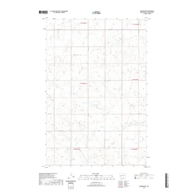
2020 Map of Manning NW
USGS Topo · Published 2020About this map
Crooked Creek meanders through this section of Dunn County, providing the primary drainage for a landscape defined by its high-plains topography. Located within the Public Land Survey System designations of T144N R97W and T143N R97W, the area is partitioned by a strict grid of section lines and gravel roads. Local travel is facilitated by a network of numbered routes such as 12th St SW and 116th Ave SW, which follow the township and range boundaries typical of North Dakota's agricultural interior. The absence of named settlements or heavy industry highlights the open, rural character of this region, where the terrain is marked primarily by the seasonal flow of Crooked Creek and the occasional farmstead access point along 17th St SW and 19th St SW.
Find a feature on this map
15 named features on this map. Tap any name to fly to it.
Don’t see what you’re looking for? This feature index may not catch every label — zoom into the map to look around manually.
Map Details
Editions of this 2020 Manning NW Map
This is the sole edition of this map. No revisions or reprints were ever made.
Other maps of this area

1953 · Watford City
USGS Topo · 1:250,000

1957 · Watford City
USGS Topo · 1:250,000

1963 · Fairfield SE
USGS Topo · 1:24,000

1963 · Hungry Man Butte
USGS Topo · 1:24,000

1967 · Watford City
USGS Topo · 1:250,000

1973 · Manning SE
USGS Topo · 1:24,000
1973 · New Hradec North
USGS Topo · 1:24,000

1973 · Manning
USGS Topo · 1:24,000

1973 · Manning NW
USGS Topo · 1:24,000

1974 · Killdeer
USGS Topo · 1:100,000