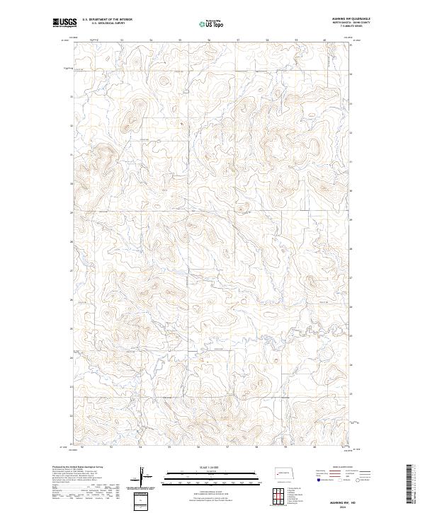
2024 Map of Manning NW
USGS Topo · Published 2024About this map
Crooked Creek meanders through the southern portions of this Dunn County landscape, carving a distinct valley through the high plains of western North Dakota. The area is defined by a rigorous section line road network, including thoroughfares like 12th St SW and 116th Ave SW, reflecting the systematic Public Land Survey System that partitioned the prairie for ranching and agriculture. The terrain rises and falls with characteristic high-elevation contours, occasionally interrupted by the drainages that feed into the local creek system. This 2024 map documents the modern rural infrastructure of the region, where long stretches of gravel roads like 18th St SW and 113th Ave SW connect isolated homesteads across several townships, maintaining the same land divisions established over a century ago.
Find a feature on this map
15 named features on this map. Tap any name to fly to it.
Don’t see what you’re looking for? This feature index may not catch every label — zoom into the map to look around manually.
Map Details
Editions of this 2024 Manning NW Map
This is the sole edition of this map. No revisions or reprints were ever made.
Other maps of this area

1953 · Watford City
USGS Topo · 1:250,000

1957 · Watford City
USGS Topo · 1:250,000

1963 · Fairfield SE
USGS Topo · 1:24,000

1963 · Hungry Man Butte
USGS Topo · 1:24,000

1967 · Watford City
USGS Topo · 1:250,000

1973 · Manning SE
USGS Topo · 1:24,000
1973 · New Hradec North
USGS Topo · 1:24,000

1973 · Manning
USGS Topo · 1:24,000

1973 · Manning NW
USGS Topo · 1:24,000

1974 · Killdeer
USGS Topo · 1:100,000