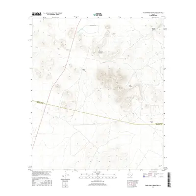
2016 Map of Mano Prieto Mountain
USGS Topo · Published 2016About this map
Mano Prieto Mountain rises as the central landmark of this West Texas landscape, situated along the county boundary marked by Jeff Davis Co and Presidio Co. This high-desert terrain is defined by its complex drainage network, where seasonal waterways like S Fork Cienega Cr and Musquiz Cr have carved prominent relief into the earth. To the east, the Puertacitas Mountains dominate the horizon, featuring the deep incision of Pine Canyon. The map reveals a land utilized for ranching and passage, evidenced by the N Mano Prieto Loop road and several significant natural troughs, including Cuervo Draw, Ponder Draw, and Greenlee Draw. These features suggest a landscape where water management and natural corridors dictate the movement of both people and livestock through the arid canyons.
Find a feature on this map
11 named features on this map. Tap any name to fly to it.
Don’t see what you’re looking for? This feature index may not catch every label — zoom into the map to look around manually.
Map Details
Editions of this 2016 Mano Prieto Mountain Map
This is the sole edition of this map. No revisions or reprints were ever made.
Other maps of this area

1894 · Valentine
USGS Topo · 1:125,000

1894 · Fort Davis
USGS Topo · 1:125,000

1895 · Marfa
USGS Topo · 1:125,000

1895 · Alpine
USGS Topo · 1:125,000

1897 · Valentine
USGS Topo · 1:125,000

1897 · Fort Davis
USGS Topo · 1:125,000

1943 · Valentine
USGS Topo · 1:125,000

1954 · Fort Stockton
USGS Topo · 1:250,000

1958 · Fort Stockton
USGS Topo · 1:250,000

1959 · Marfa
USGS Topo · 1:250,000