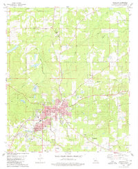
1980 Map of Mansfield
USGS Topo · Published 1980About this map
Mansfield serves as the focal point of this De Soto Parish landscape, showing the town's structural layout in 1980 along the Kansas City Southern corridor. The map highlights the intersection of local industry and civic life, featuring the Courthouse, Hosp, and several educational facilities like De Soto High Sch. Significant historical preservation is evident at the Mansfield Battle Memorial Park to the southeast, marking a pivotal site of local heritage.
Find a feature on this map
55 named features on this map. Tap any name to fly to it.
Don’t see what you’re looking for? This feature index may not catch every label — zoom into the map to look around manually.
Map Details
Editions of this 1980 Mansfield Map
This is the sole edition of this map. No revisions or reprints were ever made.
Other maps of this area

1941 · Pelican
USGS Topo · 1:62,500

1943 · Pleasant Hill
USGS Topo · 1:62,500

1944 · Logansport
USGS Topo · 1:62,500

1944 · Pleasant Hill
USGS Topo · 1:62,500

1945 · Grand Cane
USGS Topo · 1:62,500

1945 · Mansfield
USGS Topo · 1:62,500

1947 · Mansfield
USGS Topo · 1:62,500

1953 · Alexandria
USGS Topo · 1:250,000

1955 · Shreveport
USGS Topo · 1:250,000

1955 · Alexandria
USGS Topo · 1:250,000