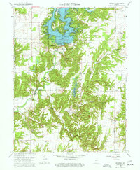
1963 Map of Mansfield
USGS Topo · Published 1964About this map
Cecil M Harden Lake dominates the northern landscape of this Parke County survey, reflecting a period of significant water management and recreation development along Big Raccoon Creek. The creation of the reservoir at the Raccoon Lake State Recreation Area stands in contrast to the traditional rural patterns established in the southern half of the map. In these areas, the network of old roads like New Discovery Road and Greencastle Road connects small communities and family landmarks.
Find a feature on this map
42 named features on this map. Tap any name to fly to it.
Don’t see what you’re looking for? This feature index may not catch every label — zoom into the map to look around manually.
Map Details
Editions of this 1963 Mansfield Map
4 editions found
Other maps of this area

1950 · Brazil East
USGS Topo · 1:24,000

1950 · Brazil West
USGS Topo · 1:24,000

1951 · Clinton Falls
USGS Topo · 1:24,000

1951 · Mansfield
USGS Topo · 1:24,000

1952 · Catlin
USGS Topo · 1:24,000

1952 · Reelsville
USGS Topo · 1:24,000

1953 · Indianapolis
USGS Topo · 1:250,000

1955 · Rockville
USGS Topo · 1:24,000

1955 · Russellville
USGS Topo · 1:24,000

1956 · Indianapolis
USGS Topo · 1:250,000