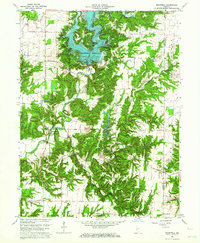
1963 Map of Mansfield
USGS Topo · Published 1973About this map
Mansfield Reservoir and the winding Big Raccoon Creek dominate this central Indiana landscape, illustrating the management of the Raccoon Creek valley in the early 1960s. The village of Mansfield sits at a strategic bend in the river, notable for its historic Covered Bridge and a nearby gaging station. This period shows the development of the Raccoon Lake State Recreation Area, which transformed the local topography into a regional destination for water-based activity.
Find a feature on this map
32 named features on this map. Tap any name to fly to it.
Don’t see what you’re looking for? This feature index may not catch every label — zoom into the map to look around manually.
Map Details
Editions of this 1963 Mansfield Map
4 editions found
Other maps of this area

1950 · Brazil East
USGS Topo · 1:24,000

1950 · Brazil West
USGS Topo · 1:24,000

1951 · Clinton Falls
USGS Topo · 1:24,000

1951 · Mansfield
USGS Topo · 1:24,000

1952 · Catlin
USGS Topo · 1:24,000

1952 · Reelsville
USGS Topo · 1:24,000

1953 · Indianapolis
USGS Topo · 1:250,000

1955 · Rockville
USGS Topo · 1:24,000

1955 · Russellville
USGS Topo · 1:24,000

1956 · Indianapolis
USGS Topo · 1:250,000