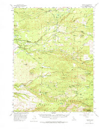
1956 Map of Manton
USGS Topo · Published 1964About this map
Manton and Shingletown sit at the center of this mid-century landscape where water power and ranching define the local economy. The complex drainage systems of North Fork Battle Creek and its southern counterpart are heavily engineered with structures like Volla Powerhouse, Inskip Powerhouse, and South Powerhouse. These hydroelectric facilities, connected by a network of ditches and siphons, reflect the region's role in generating power from the Sierra Nevada runoff.
Find a feature on this map
82 named features on this map. Tap any name to fly to it.
Don’t see what you’re looking for? This feature index may not catch every label — zoom into the map to look around manually.
Map Details
Editions of this 1956 Manton Map
2 editions found

Other maps of this area

1886 · Lassen Peak
USGS Topo · 1:250,000

1890 · Red Bluff
USGS Topo · 1:250,000

1892 · Lassen Peak
USGS Topo · 1:250,000

1894 · Lassen Peak
USGS Topo · 1:250,000

1894 · Red Bluff
USGS Topo · 1:250,000

1901 · Redding
USGS Topo · 1:125,000

1905 · Tehama
USGS Topo · 1:62,500

1935 · Burney
USGS Topo · 1:96,000

1935 · Paynes Creek
USGS Topo · 1:96,000

1939 · Burney
USGS Topo · 1:125,000