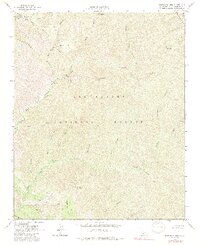
1964 Map of Manzanita Mtn.
USGS Topo · Published 1991About this map
Manzanita Mountain dominates the central landscape of this mid-century survey within the Los Padres National Forest. The map documents a complex drainage network where the North Fork La Brea Creek and South Fork La Brea Creek converge, alongside numerous canyons such as Script Canyon No 1, Script Canyon No 2, and Rattlesnake Canyon. This 1964 field-checked record shows a terrain managed for recreation and resource extraction, notably featuring the White Elephant Mine and several primitive sites like Wagon Flat Campground and Lazy Campground. Access is defined by a system of firebreaks and the winding Smith Road, which traverses Buckhorn Ridge. The presence of Horseshoe Spring and various mountain campgrounds reflects the area's development for backcountry use prior to the late 20th century.
Find a feature on this map
33 named features on this map. Tap any name to fly to it.
Don’t see what you’re looking for? This feature index may not catch every label — zoom into the map to look around manually.
Map Details
Editions of this 1964 Manzanita Mtn. Map
4 editions found
Other maps of this area

1902 · Santa Ynez
USGS Topo · 1:125,000

1905 · Santa Ynez
USGS Topo · 1:125,000

1905 · Lompoc
USGS Topo · 1:125,000

1912 · McKittrick
USGS Topo · 1:125,000

1937 · Branch Mtn
USGS Topo · 1:48,000

1941 · Caliente Mountain
USGS Topo · 1:62,500

1941 · McPherson Peak
USGS Topo · 1:62,500

1942 · Lompoc
USGS Topo · 1:125,000

1942 · Branch Mountain
USGS Topo · 1:62,500

1942 · Caliente Mtn
USGS Topo · 1:62,500