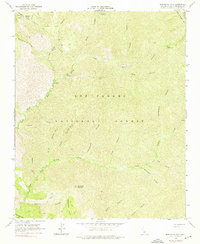
1964 Map of Manzanita Mtn
USGS Topo · Published 1976About this map
Los Padres National Forest contains a complex network of canyons and ridges in this 1960s study of the Santa Barbara backcountry. The landscape is defined by the winding course of La Brea Creek and its various tributaries, including the North Fork and South Fork. Evidence of early 20th-century resource extraction remains at the White Elephant Mine, while a system of firebreaks and jeep trails crisscrosses the high ground around Buckhorn Ridge and Manzanita Mountain. The presence of numerous designated campsites such as Wagon Flat Campground, Jesse Campground, and Kerry Canyon Campground suggests the area's established role as a recreational refuge. Water sources like Horseshoe Spring and Spring are critical landmarks within the arid, folded terrain of the Sierra Madre Mts, which dominate the northeast corner of the quadrangle.
Find a feature on this map
36 named features on this map. Tap any name to fly to it.
Don’t see what you’re looking for? This feature index may not catch every label — zoom into the map to look around manually.
Map Details
Editions of this 1964 Manzanita Mtn Map
4 editions found
Other maps of this area

1902 · Santa Ynez
USGS Topo · 1:125,000

1905 · Santa Ynez
USGS Topo · 1:125,000

1905 · Lompoc
USGS Topo · 1:125,000

1912 · McKittrick
USGS Topo · 1:125,000

1937 · Branch Mtn
USGS Topo · 1:48,000

1941 · Caliente Mountain
USGS Topo · 1:62,500

1941 · McPherson Peak
USGS Topo · 1:62,500

1942 · Lompoc
USGS Topo · 1:125,000

1942 · Branch Mountain
USGS Topo · 1:62,500

1942 · Caliente Mtn
USGS Topo · 1:62,500