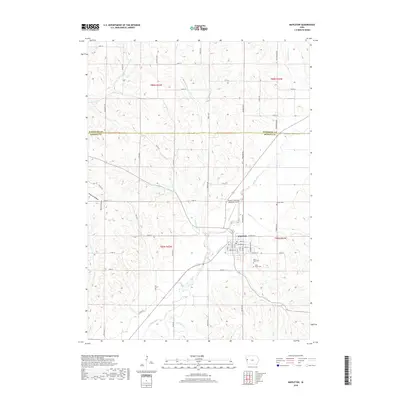
2018 Map of Mapleton
USGS Topo · Published 2018About this map
Mapleton serves as the central hub of this western Iowa landscape, situated at the confluence of several prominent waterways including the Maple River and Heisler Cr. The town's grid is detailed with residential streets like S 4th St and S 6th St, leading toward community landmarks such as James G Whiting Memorial Field. For those tracing local heritage, the area maintains several burial grounds, including Mount Hope Cem, Saint Marys Cem, and the more isolated Heisler Cem to the northeast.
Find a feature on this map
59 named features on this map. Tap any name to fly to it.
Don’t see what you’re looking for? This feature index may not catch every label — zoom into the map to look around manually.
Map Details
Editions of this 2018 Mapleton Map
This is the sole edition of this map. No revisions or reprints were ever made.
Other maps of this area

1954 · Fort Dodge
USGS Topo · 1:250,000

1957 · Fort Dodge
USGS Topo · 1:250,000

1958 · Fort Dodge
USGS Topo · 1:250,000

1969 · Danbury
USGS Topo · 1:24,000

1969 · Holstein SW
USGS Topo · 1:24,000

1969 · Mapleton
USGS Topo · 1:24,000

1969 · Castana
USGS Topo · 1:24,000
1969 · Smithland
USGS Topo · 1:24,000
1969 · Oto
USGS Topo · 1:24,000
1969 · Correctionville SE
USGS Topo · 1:24,000