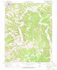
1963 Map of Maramec Spring
USGS Topo · Published 1971About this map
Maramec Spring and the Old Iron Furnace anchor this 1963 survey of the northern Ozark borderlands, where the landscape transitions from the developed community of St James to the deeply dissected valleys of the Meramec River. This area is marked by a complex network of hollows, including Asher Hollow and Brown Hollow, which drain into the river system. The presence of several family and community burial grounds, such as Hankins Cem, Maramec Cem, and the Masonic Cemetery, provides a wealth of data for those tracing local lineages. Natural landmarks like Natural Bridge and Marcelus Cave highlight the region's karst topography, while the Asher Lookout Tower and Claypits indicate the era's local industry and forest management. Small settlements like Earle and the Boys Town of Missouri further define the mid-century human geography of Phelps County.
Find a feature on this map
30 named features on this map. Tap any name to fly to it.
Don’t see what you’re looking for? This feature index may not catch every label — zoom into the map to look around manually.
Map Details
Editions of this 1963 Maramec Spring Map
4 editions found
Other maps of this area

1903 · Sullivan
USGS Topo · 1:125,000

1928 · Meramec Spring
USGS Topo · 1:62,500

1932 · Steelville
USGS Topo · 1:48,000

1933 · Steelville
USGS Topo · 1:62,500

1934 · Redbird
USGS Topo · 1:62,500

1937 · Steelville
USGS Topo · 1:62,500

1938 · Redbird
USGS Topo · 1:62,500

1948 · Cuba
USGS Topo · 1:24,000

1949 · Saint Louis
USGS Topo · 1:250,000

1949 · Rolla
USGS Topo · 1:250,000