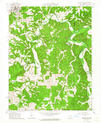
1963 Map of Meramec Spring
USGS Topo · Published 1964About this map
Meramec Spring and the Old Iron Furnace anchor this section of the Ozark Highlands, where the Meramec River begins its course through a landscape of deep hollows and timbered ridges. The map records the early industrial roots of the region alongside mid-century developments like the Boys Town of Missouri and the Asher Lookout Tower. Cultural history is well-preserved through a network of small family and community burial grounds, including the Masonic Cemetery, Hawkins Cem, and Adams Cem, which are scattered among the drainages of Dry Fork and Piney Creek. Geologic features like the Natural Bridge and Marcellus Cave illustrate the karst topography that defines the Phelps and Crawford County border. The presence of Claypits and a Gravel Pit indicates the ongoing extractive economy that followed the era of the historic iron furnace.
Find a feature on this map
30 named features on this map. Tap any name to fly to it.
Don’t see what you’re looking for? This feature index may not catch every label — zoom into the map to look around manually.
Map Details
Editions of this 1963 Meramec Spring Map
4 editions found
Other maps of this area

1903 · Sullivan
USGS Topo · 1:125,000

1928 · Meramec Spring
USGS Topo · 1:62,500

1932 · Steelville
USGS Topo · 1:48,000

1933 · Steelville
USGS Topo · 1:62,500

1934 · Redbird
USGS Topo · 1:62,500

1937 · Steelville
USGS Topo · 1:62,500

1938 · Redbird
USGS Topo · 1:62,500

1948 · Cuba
USGS Topo · 1:24,000

1949 · Saint Louis
USGS Topo · 1:250,000

1949 · Rolla
USGS Topo · 1:250,000