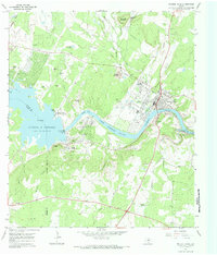
1967 Map of Marble Falls
USGS Topo · Published 1985About this map
Lake Marble Falls and the Colorado River dominate this Central Texas landscape during a period of significant hydroelectric and recreational development. The town of Marble Falls sits at the center of a complex water system, positioned between the Alvin Wirtz Dam to the west and the Max Starcke Dam to the east. This 1967 survey captures the area as the newly renamed Lake Lyndon B Johnson became a focal point for regional leisure, illustrated by the Kelly A F B Recreation Area and various picnic zones along the shoreline.
Find a feature on this map
53 named features on this map. Tap any name to fly to it.
Don’t see what you’re looking for? This feature index may not catch every label — zoom into the map to look around manually.
Map Details
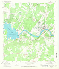
Editions of this 1967 Marble Falls Map
2 editions found
Other maps of this area

1887 · Blanco
USGS Topo · 1:125,000

1887 · Burnet
USGS Topo · 1:125,000

1893 · Burnet
USGS Topo · 1:125,000

1894 · Blanco
USGS Topo · 1:125,000

1903 · Burnet
USGS Topo · 1:125,000

1909 · Burnet
USGS Topo · 1:125,000

1925 · Burnet 3-b
USGS Topo · 1:48,000

1925 · Burnet 3-d
USGS Topo · 1:48,000

1929 · Marble Falls
USGS Topo · 1:62,500

1931 · Marble Falls
USGS Topo · 1:48,000