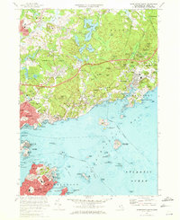
1970 Map of Marblehead North
USGS Topo · Published 1972About this map
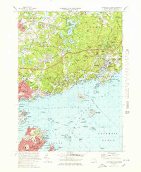
Massachusetts Bay defines the character of this coastal landscape, where the seafaring heritage of Marblehead and Beverly meets the wooded hills of the interior. The shoreline is punctuated by historic landmarks including Fort Sewall, the Marblehead Lighthouse, and Lighthouse Hospital Pt, reflecting the maritime importance of Salem Harbor and Marblehead Harbor. Inland, the terrain rises toward heights like Browns Hill and Wyman Hill, sheltering numerous small bodies of water such as Chebacco Lake and Coy Pond. The presence of Gordon College near South Hamilton and the Boston and Maine railroad corridor illustrates the 20th-century development of these North Shore communities. From the U S Coast Guard Air Station on the water to the Iron Rail Girls Camp in Wenham, the map records a balance of residential growth, educational institutions, and preserved coastal terrain.
Find a feature on this map
137 named features on this map. Tap any name to fly to it.
Don’t see what you’re looking for? This feature index may not catch every label — zoom into the map to look around manually.
Map Details
Editions of this 1970 Marblehead North Map
2 editions found
Other maps of this area

1886 · Gloucester
USGS Topo · 1:62,500

1888 · Gloucester
USGS Topo · 1:62,500

1888 · Salem
USGS Topo · 1:62,500

1892 · Boston Bay
USGS Topo · 1:62,500

1893 · Salem
USGS Topo · 1:62,500

1893 · Gloucester
USGS Topo · 1:62,500

1903 · Boston Bay
USGS Topo · 1:62,500

1917 · Salem
USGS Topo · 1:62,500

1918 · Gloucester
USGS Topo · 1:62,500

1919 · Salem
USGS Topo · 1:62,500