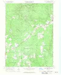
1967 Map of Marienville West
USGS Topo · Published 1971About this map
The Allegheny National Forest and Kittanning State Forest dominate this Pennsylvanian landscape, where resource extraction and conservation meet at the Clarion and Forest county line. The Baltimore and Ohio railroad cuts a diagonal path across the terrain, linking small settlements like Gilfoyle and Vowinckel that were built around the local timber and rail economy. High points are marked by landmarks like the Muzette Lookout Tower, while the valley floors are dotted with numerous gas wells, signaling the era's active industrial footprint.
Find a feature on this map
40 named features on this map. Tap any name to fly to it.
Don’t see what you’re looking for? This feature index may not catch every label — zoom into the map to look around manually.
Map Details
Editions of this 1967 Marienville West Map
Other maps of this area

1918 · Loleta
USGS Topo · 1:62,500

1922 · Tionesta
USGS Topo · 1:62,500

1924 · Tionesta
USGS Topo · 1:62,500

1927 · Tidioute
USGS Topo · 1:48,000

1930 · Tidioute
USGS Topo · 1:62,500

1935 · Sheffield
USGS Topo · 1:48,000

1936 · Marienville
USGS Topo · 1:48,000

1941 · Sheffield
USGS Topo · 1:62,500

1941 · Marienville
USGS Topo · 1:62,500

1946 · Tionesta
USGS Topo · 1:62,500