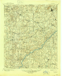
1901 Map of Marietta
USGS Topo · Published 1944About this map
The Chattahoochee River serves as a central artery for this late 19th-century landscape, a period when local travel and commerce relied heavily on established river crossings such as Pumpkintown Ferry, Campbellton Ferry, and Morris Ferry. The settlement pattern reflects a pre-suburban era of North Georgia, where industrial activity was defined by water-powered operations like Allen Mills and Daniells Mills. The rail network, including the Southern and Birmingham Div and the West Point and Atlanta Railroad, connects established hubs like Marietta and Dallas with smaller, now-obscured junctions.
Find a feature on this map
106 named features on this map. Tap any name to fly to it.
Don’t see what you’re looking for? This feature index may not catch every label — zoom into the map to look around manually.
Map Details
Editions of this 1901 Marietta Map
4 editions found

Other maps of this area

1886 · Rome
USGS Topo · 1:125,000

1888 · Atlanta
USGS Topo · 1:125,000

1889 · Tallapoosa
USGS Topo · 1:125,000

1890 · Suwanee
USGS Topo · 1:125,000

1890 · Cartersville
USGS Topo · 1:125,000

1890 · Atlanta
USGS Topo · 1:125,000

1891 · Marietta
USGS Topo · 1:125,000

1891 · Cartersville
USGS Topo · 1:125,000

1892 · Tallapoosa
USGS Topo · 1:125,000

1892 · Atlanta
USGS Topo · 1:125,000