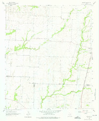
1961 Map of Marilee
USGS Topo · Published 1975About this map
Marilee and the southern outskirts of Gunter occupy this North Texas landscape at the border of Grayson and Collin counties. The terrain is defined by a dense network of waterways, including Little Elm Creek, Buck Creek, and Mustang Creek, which weave through the agricultural parcels of the region. The St Louis San Francisco and Texas railroad serves as the primary industrial corridor, running north-south through the eastern half of the map and connecting the small communities. Local life and history are anchored by landmarks like the Mt Carmel Ch and Gunter Cem, while the presence of an Oil Well and a Quarry suggests the early diversification of the rural economy beyond farming. The intricate system of small tributaries like Clarks Branch and Fork Walnut Creek highlights the natural drainage patterns that shaped the placement of roads and homesteads during this era of development.
Find a feature on this map
17 named features on this map. Tap any name to fly to it.
Don’t see what you’re looking for? This feature index may not catch every label — zoom into the map to look around manually.
Map Details
Editions of this 1961 Marilee Map
2 editions found
Other maps of this area

1901 · Denison
USGS Topo · 1:125,000

1954 · Sherman
USGS Topo · 1:250,000

1958 · Dorchester
USGS Topo · 1:24,000

1958 · Whitesboro
USGS Topo · 1:62,500

1958 · Sherman
USGS Topo · 1:250,000

1958 · Sherman
USGS Topo · 1:62,500

1960 · Celina
USGS Topo · 1:24,000

1960 · Aubrey
USGS Topo · 1:24,000

1961 · Gunter
USGS Topo · 1:24,000

1961 · Pilot Point
USGS Topo · 1:24,000