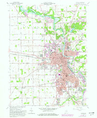
1961 Map of Marion
USGS Topo · Published 1982About this map
The Mississinewa River winds through the heart of this Indiana landscape, anchoring the industrial and civic life of Marion. The city’s mid-century footprint is dense with local institutions, from Marion College in the south to the historic Courthouse and City Hall downtown. The industrial character of the era is evidenced by the intersection of major rail lines, including the Conrail, Norfolk and Western, and Chesapeake and Ohio railroads, which serviced the factories and warehouses near the riverbanks.
Find a feature on this map
85 named features on this map. Tap any name to fly to it.
Don’t see what you’re looking for? This feature index may not catch every label — zoom into the map to look around manually.
Map Details
Editions of this 1961 Marion Map
3 editions found
Other maps of this area

1950 · Mount Etna
USGS Topo · 1:24,000

1951 · Mount Etna
USGS Topo · 1:24,000

1953 · La Fontaine
USGS Topo · 1:24,000

1953 · Somerset
USGS Topo · 1:24,000

1953 · Muncie
USGS Topo · 1:250,000

1956 · Muncie
USGS Topo · 1:250,000

1960 · Point Isabel
USGS Topo · 1:24,000

1960 · Fairmount
USGS Topo · 1:24,000

1960 · Gas City
USGS Topo · 1:24,000

1961 · Marion
USGS Topo · 1:24,000