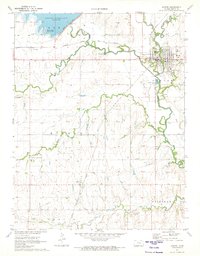
1971 Map of Marion
USGS Topo · Published 1973About this map
Marion Reservoir dominates the northwestern corner of this Kansas landscape, where the Hillsboro Cove Public Use Area meets the northern reaches of the North Cottonwood River. The town of Marion serves as a central hub, situated at the confluence of several waterways and rail lines. The transportation network of the early 1970s is well-defined, showing the paths of the Atchison Topeka and Santa Fe and the Chicago Rock Island and Pacific railroads as they navigate the river valleys.
Find a feature on this map
31 named features on this map. Tap any name to fly to it.
Don’t see what you’re looking for? This feature index may not catch every label — zoom into the map to look around manually.
Map Details
Editions of this 1971 Marion Map
2 editions found
Other maps of this area

1889 · Newton
USGS Topo · 1:125,000

1894 · Newton
USGS Topo · 1:125,000

1898 · Cottonwood Falls
USGS Topo · 1:125,000

1955 · Hutchinson
USGS Topo · 1:250,000

1957 · Peabody NW
USGS Topo · 1:24,000

1957 · Florence
USGS Topo · 1:24,000

1957 · Lincolnville SW
USGS Topo · 1:24,000

1957 · Peabody
USGS Topo · 1:24,000

1959 · Hutchinson
USGS Topo · 1:250,000

1971 · Durham
USGS Topo · 1:24,000