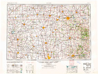
1962 Map of Marion
USGS Topo · Published 1962About this map
Central Ohio's agricultural and industrial corridor unfolds across this mid-century survey, centered on the rail hubs of Marion, Mansfield, and Bucyrus. The landscape is defined by the headwaters of several major river systems, including the Sandusky River flowing north and the Scioto River and Olentangy River trending south. This period captures the post-war infrastructure boom, where traditional settlements like Upper Sandusky and Mount Blanchard are linked by an expanding highway network including U.S. 30 and U.S. 42. To the east, the terrain shifts near French Ridge as the flat till plains give way to the more dissected landscapes near the Mohican River and Walhonding River. Large-scale water management is evident through the presence of the Charles Mill Reservoir and Pleasant Hill Reservoir, highlighting the era's focus on flood control and recreation in the Muskingum watershed.
Find a feature on this map
147 named features on this map. Tap any name to fly to it.
Don’t see what you’re looking for? This feature index may not catch every label — zoom into the map to look around manually.
Map Details
Editions of this 1962 Marion Map
This is the sole edition of this map. No revisions or reprints were ever made.
Other maps of this area

1901 · Dublin
USGS Topo · 1:62,500
1901 · Fostoria
USGS Topo · 1:62,500

1901 · Wooster
USGS Topo · 1:62,500

1902 · Westerville
USGS Topo · 1:62,500
1903 · Wooster
USGS Topo · 1:62,500

1903 · Dublin
USGS Topo · 1:62,500
1903 · Fostoria
USGS Topo · 1:62,500
1903 · Findlay
USGS Topo · 1:62,500
1903 · Marion
USGS Topo · 1:62,500

1904 · Westerville
USGS Topo · 1:62,500