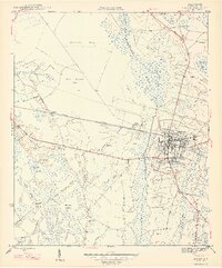
1947 Map of Marion
USGS Topo · Published 1947About this map
The town of Marion serves as the focal point of this coastal plain landscape, where the Atlantic Coast Line railroad bisects the terrain. The settlement pattern is defined by a heavy reliance on the surrounding wetland systems, including the expansive Catfish Swamp and Gum Swamp Bay. The map reveals a deeply rooted rural community, marked by a high density of named family cemeteries and country churches such as Rose Hill Cem, Durant Cem, and Shiloh Ch. These landmarks, along with Springville Sch and Singletary Sch, illustrate the social infrastructure of Marion County in the mid-1940s. The intricate network of waterways like Millrace Stream and Catfish Canal suggests a history of drainage and land management essential for agriculture and settlement in this swampy region of South Carolina.
Find a feature on this map
35 named features on this map. Tap any name to fly to it.
Don’t see what you’re looking for? This feature index may not catch every label — zoom into the map to look around manually.
Map Details
Editions of this 1947 Marion Map
3 editions found
Other maps of this area

1940 · Florence East
USGS Topo · 1:62,500

1943 · Gum Swamp
USGS Topo · 1:62,500

1945 · Florence East
USGS Topo · 1:62,500

1946 · Mullins
USGS Topo · 1:24,000

1947 · Friendship
USGS Topo · 1:24,000

1947 · Marion
USGS Topo · 1:24,000

1947 · Centenary
USGS Topo · 1:24,000

1947 · Mullins
USGS Topo · 1:24,000

1953 · Florence
USGS Topo · 1:250,000

1954 · Florence
USGS Topo · 1:250,000