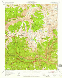
1953 Map of Marion Peak
USGS Topo · Published 1958About this map
Kings Canyon National Park dominates this high-altitude landscape as it was surveyed in the early 1950s. The geography is defined by the dramatic confluence of the Middle Fork Kings River and South Fork Kings River, where deep canyons give way to granite summits like Marion Peak and State Peak. Settlement is minimal, focused on the riverside at Cedar Grove and the historical location of Kanawyers, while the rest of the terrain remains accessible only via a network of primitive routes. Footpaths and the famous Muir Trail provide the only passage through remote areas such as the Gorge of Despair and over Granite Pass. The map details a complex alpine environment of glacial origin, featuring numerous high-country water bodies including Lake Basin, State Lakes, and the Horseshoe Lakes. These features, along with meadowlands like Zumwalt Meadows, illustrate a protected wilderness before more modern visitor infrastructure was established.
Find a feature on this map
130 named features on this map. Tap any name to fly to it.
Don’t see what you’re looking for? This feature index may not catch every label — zoom into the map to look around manually.
Map Details
Editions of this 1953 Marion Peak Map
4 editions found

Other maps of this area

1903 · Tehipite
USGS Topo · 1:125,000

1905 · Tehipite
USGS Topo · 1:125,000

1907 · Mt. Whitney
USGS Topo · 1:125,000

1912 · Mt. Goddard
USGS Topo · 1:125,000

1913 · Bishop
USGS Topo · 1:125,000

1919 · Mt. Whitney
USGS Topo · 1:125,000

1937 · Mt. Whitney
USGS Topo · 1:125,000

1947 · Mariposa
USGS Topo · 1:250,000

1948 · Fresno
USGS Topo · 1:250,000

1948 · Mariposa
USGS Topo · 1:250,000