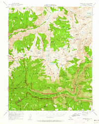
1953 Map of Marion Peak
USGS Topo · Published 1963About this map
Tunemah Peak and the high granite spires of the Marion Peak region dominate this mid-century survey of the southern Sierra Nevada. The map documents the wilderness as it was managed before the modern era of high-traffic backcountry recreation, featuring the storied Muir Trail as it traverses the Sequoia Kings Canyon National Park border. The drainage of the Middle Fork Kings River is captured in detail, showing historical stopping points like the Kanawyers site and the established grounds at Cedar Grove.
Find a feature on this map
111 named features on this map. Tap any name to fly to it.
Don’t see what you’re looking for? This feature index may not catch every label — zoom into the map to look around manually.
Map Details
Editions of this 1953 Marion Peak Map
4 editions found

Other maps of this area

1903 · Tehipite
USGS Topo · 1:125,000

1905 · Tehipite
USGS Topo · 1:125,000

1907 · Mt. Whitney
USGS Topo · 1:125,000

1912 · Mt. Goddard
USGS Topo · 1:125,000

1913 · Bishop
USGS Topo · 1:125,000

1919 · Mt. Whitney
USGS Topo · 1:125,000

1937 · Mt. Whitney
USGS Topo · 1:125,000

1947 · Mariposa
USGS Topo · 1:250,000

1948 · Fresno
USGS Topo · 1:250,000

1948 · Mariposa
USGS Topo · 1:250,000