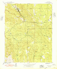
1947 Map of Mariposa
USGS Topo · Published 1948About this map
Mariposa serves as the focal point of this late-1940s survey, illustrating a community defined by its mining heritage and its role as a gateway along the Yosemite All-Year Highway. The map captures the transition from active extraction to a more settled regional hub, as evidenced by the prominence of the Mariposa Mine and Granite King Mine alongside the established County Fair Grounds.
Find a feature on this map
29 named features on this map. Tap any name to fly to it.
Don’t see what you’re looking for? This feature index may not catch every label — zoom into the map to look around manually.
Map Details
Editions of this 1947 Mariposa Map
5 editions found

Other maps of this area

1893 · Sonora
USGS Topo · 1:125,000

1896 · Sonora
USGS Topo · 1:125,000

1897 · Sonora
USGS Topo · 1:125,000

1897 · Yosemite
USGS Topo · 1:125,000

1898 · Sonora
USGS Topo · 1:125,000

1900 · Yosemite
USGS Topo · 1:125,000

1903 · Yosemite
USGS Topo · 1:125,000

1909 · Yosemite
USGS Topo · 1:125,000

1912 · Mariposa
USGS Topo · 1:125,000

1919 · Indian Gulch
USGS Topo · 1:48,000