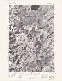
1976 Map of Markham NW
USGS Topo · Published 1979About this map
St Louis River meanders through a landscape of timber and wetlands in this mid-1970s orthophoto survey. This aerial perspective reveals the intricate drainage patterns and vegetation of St. Louis County, captured just before the emergence of more modern development in the region. To the north, the expanse of Whitewater Lake sits amidst a patchwork of clearings and wooded parcels, showing the footprint of land use and natural water retention in the Iron Range hinterlands. Unlike traditional topographic maps, this orthophoto provides a literal view of the ground cover and hydrological network as it existed in 1976, offering a clear visual record of the shoreline and river bends prior to later environmental shifts.
Find a feature on this map
2 named features on this map. Tap any name to fly to it.
Don’t see what you’re looking for? This feature index may not catch every label — zoom into the map to look around manually.
Map Details
Editions of this 1976 Markham NW Map
This is the sole edition of this map. No revisions or reprints were ever made.
Other maps of this area

1949 · Aurora
USGS Topo · 1:24,000

1949 · Allen
USGS Topo · 1:24,000

1950 · Allen
USGS Topo · 1:24,000

1950 · Aurora
USGS Topo · 1:24,000

1950 · Biwabik
USGS Topo · 1:24,000

1951 · Biwabik
USGS Topo · 1:24,000

1951 · Palo
USGS Topo · 1:24,000

1951 · Makinen
USGS Topo · 1:24,000

1954 · Hibbing
USGS Topo · 1:250,000

1957 · Hibbing
USGS Topo · 1:250,000