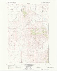
1988 Map of Markle Pass
USGS Topo · Published 1988About this map
Markle Pass and the surrounding Flathead Indian Reservation landscape are defined by a mix of highland peaks and expansive prairie floor. The 1988 data reveals a rural infrastructure centered on water management and small-scale aviation, evidenced by the Hot Springs Landing Strip and the Camas Canal tracing the terrain. The eastern edge of the map follows the winding course of the Little Bitterroot River, while the southern reaches open into the broad Camas Prairie Basin. For local historians and genealogists, the map preserves specific cultural locations such as the Markle Cem and the Oliver Gulch Sch, markers of early community development in Sanders County. The high country is anchored by Schmitz Mountain and the Schmitz Lakes, providing a detailed look at the hydrology of the Wilks Gulch area before late-century shifts in land use.
Find a feature on this map
19 named features on this map. Tap any name to fly to it.
Don’t see what you’re looking for? This feature index may not catch every label — zoom into the map to look around manually.
Map Details
Editions of this 1988 Markle Pass Map
This is the sole edition of this map. No revisions or reprints were ever made.
Other maps of this area

1920 · Flathead Lake
USGS Topo · 1:125,000

1956 · Wallace
USGS Topo · 1:250,000

1959 · Perma
USGS Topo · 1:62,500

1960 · Wallace
USGS Topo · 1:250,000

1964 · Melton Ranch
USGS Topo · 1:24,000

1964 · Markle Pass
USGS Topo · 1:24,000

1964 · Lonepine
USGS Topo · 1:24,000

1964 · Hot Springs
USGS Topo · 1:24,000
1964 · Hot Springs NE
USGS Topo · 1:24,000

1965 · Oliver Point
USGS Topo · 1:24,000