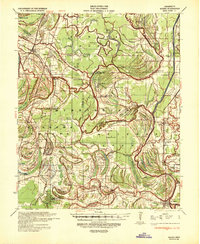
1939 Map of Marks
USGS Topo · Published 1943About this map
The Coldwater River and Yazoo River define the intricate drainage patterns of the Delta region as it appeared before the significant flood control alterations of the mid-20th century. This 1939 survey captures a landscape dominated by riparian agriculture and the extensive Yazoo and Mississippi Valley RR network, which served as the primary artery for cotton transportation. The map reveals a dense settlement pattern of rural educational and religious institutions, such as Swan Lake College, Arkadelphia Sch, and Strangers Rest Ch, which anchored these riverine communities. The interior is marked by numerous oxbow lakes like Moon Lake and Fish Lake, alongside curious landmarks like Posey Mound. Further south, the county seat of Marks and the neighboring County Farm highlight the administrative and social infrastructure of Quitman County during this era.
Find a feature on this map
173 named features on this map. Tap any name to fly to it.
Don’t see what you’re looking for? This feature index may not catch every label — zoom into the map to look around manually.
Map Details
Editions of this 1939 Marks Map
This is the sole edition of this map. No revisions or reprints were ever made.
Other maps of this area

1908 · Lula
USGS Topo · 1:24,000

1908 · Dundee
USGS Topo · 1:24,000

1908 · Coahoma
USGS Topo · 1:24,000

1908 · Moon Lake
USGS Topo · 1:24,000

1908 · Jonestown
USGS Topo · 1:24,000

1908 · Walnut Lake
USGS Topo · 1:24,000

1910 · Dundee
USGS Topo · 1:31,680

1910 · Coahoma
USGS Topo · 1:31,680

1910 · Walnut Lake
USGS Topo · 1:31,680

1910 · Jonestown
USGS Topo · 1:31,680