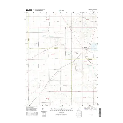
2013 Map of Marseilles
USGS Topo · Published 2013About this map
Marseilles serves as the primary community hub in this region of north-central Ohio, situated where the borders of Wyandot, Hardin, and Marion counties converge. The landscape is defined by the drainage patterns of Little Tymochtee Creek and Paupaw Run, which meander through a largely agricultural expanse organized by the Public Land Survey System. This survey reveals a remarkably high density of small family and community burial grounds, such as York Street Cem, Goodhope Cem, and Fehl Cem, reflecting the early pioneer settlement patterns of the 19th-century township divisions.
Find a feature on this map
105 named features on this map. Tap any name to fly to it.
Don’t see what you’re looking for? This feature index may not catch every label — zoom into the map to look around manually.
Map Details
Editions of this 2013 Marseilles Map
This is the sole edition of this map. No revisions or reprints were ever made.
Other maps of this area

1905 · Arlington
USGS Topo · 1:62,500

1907 · Arlington
USGS Topo · 1:24,000

1907 · Upper Sandusky
USGS Topo · 1:62,500

1915 · Kenton
USGS Topo · 1:62,500

1915 · La Rue
USGS Topo · 1:62,500

1944 · Kenton
USGS Topo · 1:62,500

1950 · Marion
USGS Topo · 1:250,000

1960 · Upper Sandusky
USGS Topo · 1:24,000

1960 · Marseilles
USGS Topo · 1:24,000
1961 · Meeker
USGS Topo · 1:24,000